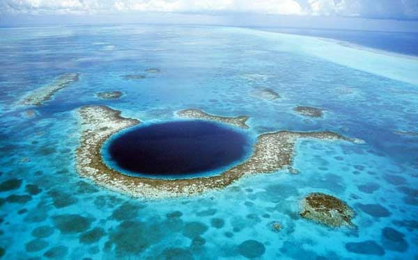
Great Blue Hole, Belize
The Great Blue Hole, off the coast of Belize is a diver's paradise.
Located next to Lighthouse Reef, about 70 kilometres off the coast of Belize, the Great Blue Hole is part of the Belize Barrier Reef Reserve System that was declared a UNESCO World Heritage Site in 1996.
Originally the Blue Hole was a limestone cave that started to form about 150,000 years ago.
Gradually the water level rose as the glacial period ended and the caves were flooded and its roof collapsed, thus forming this unique hole.

The hole was made popular by French explorer Jacques-Yves Cousteau who declared it "one of the top ten dive sites in the world."
Zangye Danxia Landform, China

Zhangye's Danxia landform has lots of precipitous red cliffs, most of which are several hundred meters high, and multicolored ridges of weathered strata, sometimes stretching to the horizon.
These formations, sometimes smooth sometimes sharp, stand out against the greens or grays of the plains , looking grand and magnificent, vigorous and virile.
Across the Danxia landscape zone, a kaleidoscope of numerous red rocky outcrops resemble weird and wonderful shapes like castles, cones, towers; as well as humans, creatures, birds and beasts.

Their peaks peeping through the mist and clouds, produce mirage-like scenery of fantastic mountains and pavilions.
The White Cliffs of Dover

The famous White Cliffs of Dover stand guard at the Gateway to England. Millions pass through Dover each year on their journey to or from the continent. In some places over 300 feet high, the White Cliffs are a symbol of the United Kingdom and a reassuring sight to travellers. The Cliffs have been immortalised in song, in literature and in art.
On a clear day you can see right across from the Dover cliffs to the cliffs on the French coast at Cap Gris Nez, proof of the continuous strata of chalk.
Around seventy million years ago this part of Britain was submerged by a shallow sea. The sea bottom was made of a white mud formed from the fragments of coccoliths, which were the skeletons of tiny algae which floated in the surface waters of the sea. This mud was later to become the chalk.
It is thought that the chalk was deposited very slowly, probably only half a millimetre a year, equivalent to about 180 coccoliths piled one on top of another. In spite of this, up to 500 metres of chalk were deposited in places.
The coccoliths are too small to be seen without a powerful microscope but if you look carefully you will find fossils of some of the larger inhabitants of the chalk sea such as sponges, shells, ammonites and urchins.

Since the time of the chalk sea, the chalk has been lifted out of the water by movements of the earth's crust. Most of the shaping of the beautiful chalk downlands we see today took place during the last Ice Age.
The latter part of the Ice Age also saw the invasion of chalk by the English Channel. The consequence of this was that Britain became an island.
Northern Lights

The bright dancing lights of the aurora are actually collisions between electrically charged particles from the sun that enter the earth's atmosphere. The lights are seen above the magnetic poles of the northern and southern hemispheres. They are known as 'Aurora borealis' in the north and 'Aurora australis' in the south..
Auroral displays appear in many colours although pale green and pink are the most common. Shades of red, yellow, green, blue, and violet have been reported. The lights appear in many forms from patches or scattered clouds of light to streamers, arcs, rippling curtains or shooting rays that light up the sky with an eerie glow.
Where is the best place to watch the Northern Lights?
Northern Lights can be seen in the northern or southern hemisphere, in an irregularly shaped oval centred over each magnetic pole. The lights are known as 'Aurora borealis' in the north and 'Aurora australis' in the south. Scientists have learned that in most instances northern and southern auroras are mirror-like images that occur at the same time, with similar shapes and colors.

Because the phenomena occurs near the magnetic poles, northern lights have been seen as far south as New Orleans in the western hemisphere, while similar locations in the east never experience the mysterious lights. However the best places to watch the lights (in North America) are in the northwestern parts of Canada, particularly the Yukon, Nunavut, Northwest Territories and Alaska. Auroral displays can also be seen over the southern tip of Greenland and Iceland, the northern coast of Norway and over the coastal waters north of Siberia. Southern auroras are not often seen as they are concentrated in a ring around Antarctica and the southern Indian Ocean.
Bryce Canyon National Park

Wind, water and time have eroded Bryce Canyon National Park sandstone cliffs into otherworldly characters plucked from the unconscious of a mad Viking. Rows of humanoid pillars crosshatched by rock strata look almost intentional but perfectly surreal. So silent, eerie and beautiful.
Your first view of the park is a dramatic unveiling. Wind through stands of pine trees until they break at the rim of Bryce Canyon National Park, revealing a panorama of goblins, towers and fins of a color you can't quite name. (What's the Pantone number for "Leif Erikson's Beard"?) The canyon's epic comes alive as you move through the 37-mile circuit - especially as the sun rises and sets.

Bike it, hike it, snowshoe or ride a horse. If you don't want to park, hop on the shuttle and people-watch between viewpoints. Take a cameraful of pictures no one will understand and let the giant yellow-pink monsters haunt your dreams.
Pamukkale, Turkey

Pamukkale, 18 km (11 miles) north of Denizli (map), is Turkey's foremost mineral-bath spa because of its natural beauty: hot calcium-laden waters spring from the earth and cascade over a cliff. As they cool they form dramatic travertines of hard, brilliantly white calcium that form pools.
Named the Cotton Fortress (pah-MOOK-kah-leh) in Turkish, it has been a spa since the Romans built the spa city of Hierapolis around a sacred warm-water spring.

The Antique Pool is still there, littered with marble columns from the Roman Temple of Apollo. You can swim in it for a fee.
Great Barrier Reef

The Great Barrier Reef is one of the seven wonders of the natural world, and pulling away from it, and viewing it from a greater distance, you can understand why. It is larger than the Great Wall of China and the only living thing on earth visible from space.
One of Australia's most remarkable natural gifts, the Great Barrier Reef is blessed with the breathtaking beauty of the world's largest coral reef. The reef contains an abundance of marine life and comprises of over 3000 individual reef systems and coral cays and literally hundreds of picturesque tropical islands with some of the worlds most beautiful sun-soaked, golden beaches.

Because of its natural beauty, the Great Barrier Reef has become one of the worlds most sought after tourist destinations. A visitor to the Great Barrier Reef can enjoy many experiences including snorkelling, scuba diving, aircraft or helicopter tours, bare boats (self-sail), glass-bottomed boat viewing, semi-submersibles and educational trips, cruise ship tours, whale watching and swimming with dolphins.
Iguazu Falls, Brazil and Argentina

The exquisite Iguazu Falls are also known as the Iguassu Falls and the Iguazu Falls. The magnificent spectacle of these 275 individual drops has awed tourists, locals and indigenous inhabitants for centuries. They originate from the Iguazu River and are located on the border of Brazil (in the state of Parana) and Argentina.
In fact, the Iguazu Falls are what divides the river of the same name into its upper and lower portions, a fact that has given rise to several myths and legends as to their origin. This river forms the boundary between Brazil and Argentina, making it a significant part of the political and geographical structure of the continent of South America.
The name of the falls originates from the Tupi or Guarani language, and means "big water". While the ancient Brazilian tribes knew of its thunderous beauty, it was only officially 'discovered' in 1541, when the European explorer, the Spanish Conquistador Alvar Nunez Cabeza de Vaca, came across its awe-inspiring beauty.

The Iguazu Falls stretch in width for 2.7 kilometres (or 1.7 miles). Their height varies between 60 metres (200 feet) and 82 metres (or 269 feet). This makes the Iguazu Falls taller than Niagara Falls and twice as wide.
A large proportion of the water is thrust down Devil's Throat, a long chasm that is 82 metres high, 150 metres wide and 700 metres long. This chasm has a distinguishing U-shape. Interestingly, there are several islands within the river and the falls.
Distribution of the falls between Argentina and Brazil
The Iguazu Falls are arranged in a way that resembles a reversed letter "J". The border between Brazil and Argentina runs through the Devil's Throat. On the right bank is the Brazilian territory, which has just over 20% of the jumps of these falls, and the left side jumps are Argentine, which make up almost 80% of the falls.
Jeju-do Island, South Korea

Located southwest of the Korean Peninsula, Jeju-do Island is a volcanic island in the shape of an oval that measures 73km from west to east, and 31km from north to south.
As Korea's most southern region, the weather on Jeju-do Island remains significantly warmer than the mainland even during the cold winter months.
Jeju-do Island is sometimes referred to as "Samda-do Island" meaning the "three many") because of its abundance of rocks, women, and wind.
Wind from the ocean blows steadily throughout the year and past volcanic activity has littered the island with an assortment of beautiful and unusually-shaped black rocks.

The island's reputation of having an abundance of women points back to the time when fishing was the primary means of income and many men were lost at sea.
Halong Bay, Vietnam

Halong Bay is one of the world's natural wonders, and is the most beautiful tourist destination of Vietnam. Halong Bay features more than one thousand awesome limestone karsts and islands of various sizes and shapes along the 120-km coastline of Bai Chay Beach.
Its waters are host to a great diversity of ecosystems including offshore coral reefs, freshwater swamp forests, mangrove forests, small freshwater lakes, and sandy beaches.
The folk tale has it that the dragons descended from heaven to help locals by spitting jewels and jade to the sea, forming a natural fortress against invaders; these precious stones are represented by the lush green outcrops.

Several islands boast beautiful grottos and caves with contiguous chambers, hidden ponds and peculiar stone formations. Halong Bay is about 170 kilometers northeast of Hanoi and 3,5 hours by road.