Oil and Gas exploration
A variety of technologies are employed in the oil and gas industry to identify oil and gas reserves, to access those reserves, and to extract and deliver the products. The following subsections provide an overview of current technologies employed in oil and gas exploration and drilling.
The exploration for oil and gas, which may be quite time- and effort-intensive and rely on the collection and detailed analyses of extensive geologic information, involves a number of activities, including the following..
- Surveying and mapping surface and subsurface geologic features with techniques such as seismic reflection to identify areas (called hydrocarbon traps) where oil and gas may have accumulated.
- Determining a geologic formation's potential for containing commercial quantities of economically producible oil and/or gas.
- Identifying the best locations to drill an exploratory well to test the hydrocarbon traps.
- Drilling exploration and delineation wells to determine where hydrocarbons are present and to measure the area and thickness of the oil- and/or gasbearing reservoir or reservoirs.
- Logging and coring wells to measure the permeability, porosity, and other properties of the geologic formation(s) encountered.
- Completing construction of wells and site facilities deemed capable of producing commercial quantities of oil and / or gas.
While past surveying and mapping activities employed invasive techniques that included explosive seismic profiling and extensive drilling to map and locate potential reservoirs, modern exploration involves the use of non-explosive reflection seismic profiling, together with seismic imaging software and computers, to interpret geological and geophysical data more completely.
Reflection seismic profiling transmits acoustic vibrations (seismic waves) underground. As these waves travel through different rock layers, some are reflected backward by the different subsurface layers to an array of receiving (detecting) geophones (or hydrophones, if in water).
These reflections off of subsurface layers are then used to generate multidimensional representations of the subsurface.
Onshore Seismology
In practice, using seismology for exploring onshore areas involves artificially creating seismic waves, the reflections of which are then picked up by sensitive pieces of equipment called geophones embedded in the ground or placed on the ground surface. The data picked up by these geophones are then transmitted to a seismic recording truck that records the data for further interpretation by geophysicists and petroleum reservoir engineers.
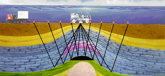
Onshore Seismology (Image comes from Terrex Seismic)
In the past, seismic waves were created using dynamite. Today, most seismic crews use nonexplosive seismic technology to generate the required data. This nonexplosive technology usually consists of wheeled or tracked vehicles carrying special equipment (a vibrator) designed to create a series of vibrations, which in turn creates seismic waves. Other seismic source include dropped weights and air guns.
Offshore Seismology
Offshore seismic exploration is similar to onshore exploration, but rather than trucks and geophones, a ship is used to convey equipment needed to generate the seismic waves and gather the seismic data, and hydrophones are used to pick up seismic waves underwater. The hydrophones are towed behind a ship in various configurations, depending on the needs of the geophysicist.
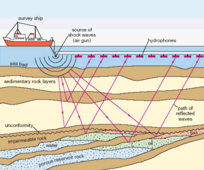
Offshore Seismology
Rather than using dynamite or impacts on the seabed floor, the seismic ship uses a large air gun that releases bursts of compressed air under water to create seismic waves that travel through the earth's crust and generate the necessary seismic reflections.
Exploratory Wells and Logging
Once a specific location has been identified as potentially containing oil and/or gas deposits, one or more exploratory wells are drilled to provide information on the composition of the underground rock layers and their geological and geophysical properties.
Drilling progresses very gradually, at a speed of a few meters per hour, slowing to just one meter an hour by the time one is down to 3,000 meters below the surface. Snags are encountered from time to time, and the entire drill-string has to be pulled out regularly for a change of drill-bit.
An exploratory well takes from three to six months to drill. Four wells out of five, or even six out of seven in pioneer zones, fail to yield commercially viable quantities of oil or gas. Sometimes, though, the drill-bit strikes a hydrocarbon-impregnated rock, in which case the drilling crew conducts extensive well-logging to find out more.
Well logging refers to performing tests during or after the drilling process to allow geologists and drill operators to monitor the progress of the well drilling, to gain a clearer picture of subsurface formations, and to identify specific rock layers, in particular those that represent target zones for further exploration. There are many different types of logging; more than 100 different logging tests can be performed to help characterize the composition and characteristics of the different layers of rock through which the well passes. Following interpretation of the logging data, a determination can be made as to whether or not to proceed with the installation of production wells. Logging is also used to monitor the drilling process and to ensure that the correct drilling equipment, materials, and supplies (such as drilling muds), are being used and that drilling is not continued if unfavorable surface or subsurface conditions develop.
Two of the most common types of logging are sample and wireline. Sample logging consists of examining and recording the physical aspects of the rock penetrated by a well. Drill cuttings (rock that is displaced by the drilling of the well) and core samples (intact underground rock samples) may be collected from the exploratory well and physically examined to describe the subsurface rock, determine the position and thickness of the various layers of rock, and estimate (with cuttings) or determine (with cores) the porosity and fluid content of the subsurface rock. Wireline logging consists of lowering a device used to measure the electrical, acoustic, or radiological properties of the rock layers into the downhole portion of the well to provide an estimate of the fluid content and characteristics of the various rock layers through which the well passes.
Related Post(s)
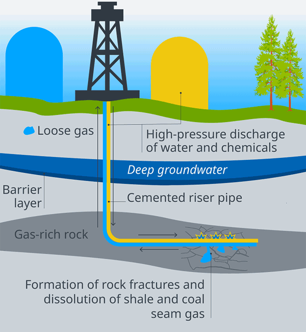
Fracking is a technique for increasing the permeability of rock so that oil, natural gas or geothermal energy can be extracted more easily...